
Cheddar Gorge
Walk Highlights
- Nearest Town:
- Cheddar
- Postcode:
- BS27 3QF
- Parking:
There are several pay and display car parks located along the B3135 road that runs through Cheddar Gorge in Somerset, as well as larger public and private car parks in Cheddar village itself at the foot of the gorge. Parking charges apply and can be expensive, especially in the privately run car parks associated with the main Gorge attractions (caves, museum etc.). Some National Trust car parks on the Mendip plateau (e.g., Black Rock or Tynings Farm, which are further out) may offer alternative starting points for longer walks onto the hills that can incorporate parts of the gorge. Arrive very early, especially during holidays and weekends, as Cheddar Gorge is an extremely popular Somerset tourist destination and parking fills rapidly.
- Distance:
- 3.50 miles
- Time:
- 1.80 hours
- Difficulty:
- Moderate
- Terrain:
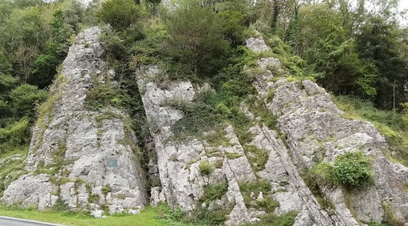
The terrain for the Cheddar Gorge Cliff-Top Walk in Somerset is challenging and strenuous. Expect very steep, rocky, and uneven paths with loose stones and scree in places. Paths can be extremely slippery when wet, particularly on the limestone. There are unfenced cliff edges in many places – extreme caution is needed at all times. Strong, sturdy walking boots with excellent ankle support and good grip are absolutely essential. This Somerset walk is not suitable for those with vertigo, a fear of heights, or limited mobility.
- Facilities:
- Toilets, Cafe, Pub Nearby
- Get Directions:
-
Get driving directions to the starting point:
Create a free account to make this useful beyond one walk
Save walks, build a shortlist, report current conditions, and join the local dog-walking community.
3-Day Dog Walking Forecast
Ground Conditions
No reports yet. Walked this recently?
Dog-Centric Details
- Poo Bins Available:
- Yes
- Secure/Fenced Area:
- No
- Dog Water Source:
- No
- Dog Notes:
The Cheddar Gorge Cliff-Top Walk in Somerset can be suitable for very fit, agile, and experienced hill-walking dogs, but extreme caution and responsible ownership are paramount. Dogs MUST be kept on short leads and under very close and effective control at all times due to the very steep, unfenced cliff edges, loose rocks, and the presence of grazing livestock (feral goats and Soay sheep roam freely on the gorge sides). This is a very strenuous walk for dogs, and care must be taken with their paws on the rocky terrain. Ensure your dog is capable and carry plenty of water for them. Some parts of the commercial Cheddar Gorge & Caves attraction at the bottom of the gorge may not allow dogs (check their policy). This Somerset walk requires dogs to be extremely well-behaved and closely supervised.
- EV Charger Nearby:
- No
- Fuel Station Nearby:
- No
- Livestock Information:
- Off-Leash Policy:
- Partial Off-Leash
- Dog Traffic:
- Busy
- Seasonal Advice:
- Height Restriction:
- No
- Printable Version:
- Open & Print
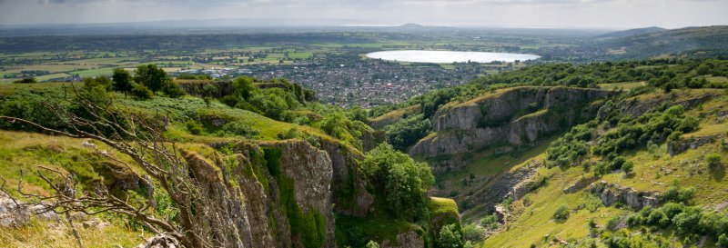
A circular dog walk at Cheddar Gorge. At almost 122 metres deep and 3 miles long, this is the largest gorge in England, with weathered crags and pinnacles.
National Trust Membership: For free parking at most National Trust car parks, and free entry to over 500 places - join here.
How to get there
For Cheddar Cliffs take A371 to Wells from Weston-Super-Mare. 8 miles north-west of Wells, signposted off M5, A371 Axbridge to Wells road and A38 Burnham to Bristol road.
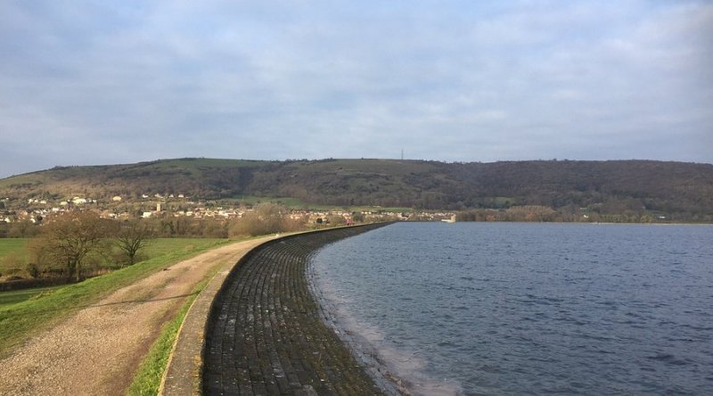
Experience the awe-inspiring natural wonder of Cheddar Gorge in Somerset, Britain's largest and most famous gorge, offering breathtaking cliff-top walks with stunning views and a unique geological landscape formed during the last Ice Age. This iconic Somerset walk takes you high above the dramatic limestone cliffs, which tower up to 450 feet, providing a thrilling and memorable experience in the Mendip Hills Area of Outstanding Natural Beauty (AONB). Cheddar Gorge is also internationally renowned for its caves (where Cheddar Man, Britain's oldest complete human skeleton, was found) and the village of Cheddar at its foot, famous for its cheese.
The National Trust manages much of the land on the north side of the Gorge, including the very popular Cheddar Gorge Cliff-Top Walk (a waymarked circular route). This route involves a steep climb from the village but rewards walkers with incredible vistas down into the gorge itself, across the Somerset Levels towards Glastonbury Tor, and even to the coast on a clear day. You can also explore Jacob's Ladder (274 steps leading to a viewpoint) and the Lookout Tower (these are usually part of the Cheddar Gorge & Caves attraction, for which a separate admission fee typically applies) for even more elevated views. This Somerset landmark is an unforgettable experience.
- Walk the spectacular cliff tops of Cheddar Gorge in Somerset, Britain's largest and most dramatic gorge.
- Experience breathtaking, unparalleled views from high above the towering limestone cliffs.
- Explore a unique geological landscape within the Mendip Hills AONB, rich in caves and history.
- Discover an area renowned for its wildlife, including feral goats, Soay sheep, and rare plants.
The main Cheddar Gorge Cliff-Top Walk is a circular route of approximately 3-4 miles and is strenuous due to the very steep ascents and descents. Allow at least 2-3 hours to complete it and to fully appreciate the views. This Somerset walk is a true adventure, requiring good fitness and a head for heights.
Walk Description
1 Head out on the lane opposite the National Trust information centre, in the lower Gorge area. Take the path leading up through the woodland. At the top of the ascent, head through the gate to join a wide grass path. Keep the stone wall to your right.
2 Follow the path to the top then along the path along the side of the Gorge before heading back down.
3 When you reach the bottom, head through the gate and go on straight ahead. Take the path through a wooded area. When the path joins the stony track, turn right through a gate to join up with the main Gorge road. Cross the road and join the path to the right.
4 When the path levels out at the top, you will join a wide grass path. Keep to the right and follow the path. Head down, descending on the grass path.
5 Follow the path downwards through the woods. Before Pavey's lookout tower, take the path heading left and down the hill through the woods. When you join Lynch Lane, turn right and then right again at the end to walk down Lippiatt Road. When you reach the junction with the main Gorge road, turn right to take the pavement back to the National Trust Information Centre.
Grid Reference: ST 466 539
Safety Disclaimer
Outdoor activities always involve an element of risk. Routes, terrain, surfaces, weather, access, livestock presence, water levels, and parking arrangements can change at any time, and path conditions may deteriorate without notice.
You are responsible for your own safety and for the safety, supervision, and wellbeing of your dogs, children, and anyone else with you. Please assess conditions for yourself before setting out and decide whether the walk is suitable for your group.
Dress appropriately for the conditions and bring suitable equipment, food, water, leads, navigation tools, and anything else needed for a safe outing. Trail Tails Ltd is not responsible for loss, damage, injury, incident, or any consequences arising from use of this information.
Help Keep This Walk Accurate
If anything has changed or looks incorrect, please send us an edit or update suggestion.
Suggest an Edit or UpdateMap
Share this walk:
Other Walks Nearby
More walks nearby
Create a free account to keep exploring nearby walks and build a shortlist.
Create Free Account
Comments & Reviews (0)
Get More From This Walk!
Create a free account to save this walk, rate it, and share your experience.
Be the first to comment on this walk!