logo logo logo logo
  • England
    • North West
    • North East
    • Yorkshire
    • West Midlands
    • East Midlands
    • East of England
    • South West
    • South East
    • Greater London
    • Lake District
    • Peak District
    • South Downs
  • Scotland
    • Highlands
    • Lowlands
    • Cairngorms
  • Wales
    • North Wales
    • South Wales
    • Anglesey
    • Snowdonia
  • Blog
    • The Dog Blog
  • Dog Friendly
    • Holiday Cottages
    • Dogs Welcome
  • Store
  • Crook Peak

    Mendip Hills, Somerset


Crook Peak

Circular walk

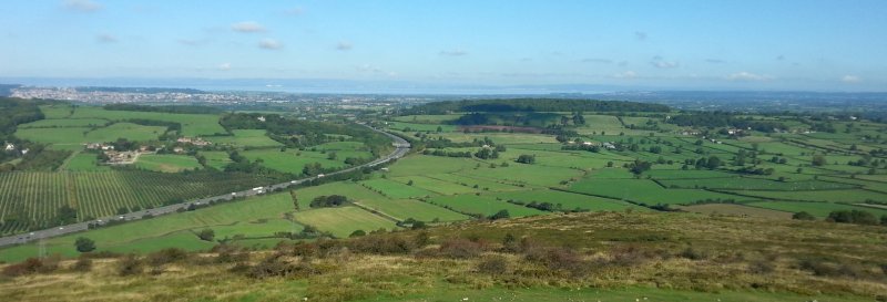
A walk on the westernmost and most mountainous of the six main peaks in the Mendip Hills, a summit topped by limestone exposures, overlooking the Somerset Levels and the Bristol Channel coastline. Downloadable map available here.

We work hard to make this website the best it can be. If you've found it useful, please consider buying us a coffee to show your support.
Buy Me a Coffee at ko-fi.com

Useful Information

How to get there: Along Webbington Road, near Compton Bishop.

Grid Reference: ST 392 550
Nearest Postcode: BS26 2HH
Parking: National Trust car park.

Distance

4.1 miles

Difficulty

Challenging

Time

2hr

Advertisement

The Walk

A walk on the westernmost of the six main summits of the Mendip Hills.

Map with thanks to Ordnance Survey.

Walk

1 The path heads northwest from the car park, passing a thin belt of trees and up to a junction on the crest of a ridge. From here the summit is a little over half a mile away, climbing with a steady though not too steep gradient.

2 From the peak, the onwards path slopes down a little to a five-way junction; three of the routes descend, and the other continues over the high ground, alongside a recently-restored section of dry stone wall, up to the minor, grassy highpoint of Compton Hill.

3 Follow the path around the head of a valley to Barton Hill, then up a little more to the summit of Wavering Down, the far side of which has views of Cheddar Reservoir and the hills around Cheddar Gorge.

4 Follow the route and descend the steeper slopes to the south, meeting another path that angles to the southwest, aiming for a patch of woodland. On the far side of the trees, the path crosses two fields and meets a country lane at the edge of Compton Bishop, from where the parking area is a short walk away. Take a look on either side of the path at two short caves - Sandy Cave on the east side, a relatively small opening near the top of the ridge, and Denny's Hole to the west, which a larger, deeper cavern with a slippery mud slope at its entrance.

Similar Walks

Two further walks to consider in the South West.

Cheddar Gorge Cheddar Gorge, Somerset - Dog Walks Near Me

1hr 45 min

Time

3.5 miles

Distance

Moderate

Difficulty

Cheddar Gorge

Circular Walk

Somerset

Poet's Walk, Clevedon Poet's Walk, Clevedon - Dog Walks Near Me

1 hrs 15 mins

Time

2.3 miles

Distance

Easy

Difficulty

Poet's Walk, Clevedon

Linear Walk

North Somerset

Enjoy this walk?

Say thanks with a coffee.

Our Affiliate Partners

North Face
client logo
Berghaus
Ordnance Survey
Jack Wolfskin UK
AATU
Dog Walks Near Me
  • Find dog walks across the UK
  • About Us
  • Sticker Competition
    (win £50)
Top Walk Areas
  • Peak District National Park
  • Lake District National Park
  • Cornwall Region
  • South East Region
Dogs Welcome
  • Find dog friendly businesses
    across the UK

  • Own a dog friendly business?
    Advertise with us (free listings
    are available)
The Dog Blog
  • A blog where we share additional content related to the wider-world

Contact Us
  • Email
© Dog Walks Near Me | Cookie & Privacy Policy