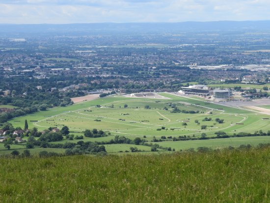
Cleeve Hill

Updated: May 29, 2025
Featured image for Cleeve Hill

Walk Highlights

Location:
Cheltenham
Postcode:
GL52 3PX
Parking:

There are several main car parks providing access to Cleeve Hill in Gloucestershire. Popular choices include the Cleeve Hill Quarry Car Park (often has a pay and display machine or an honesty box system, located on the B4632 above Prestbury) and the West Down Car Park (often free, accessed from a minor road leading from Southam). Smaller lay-bys and informal parking spots exist but can fill very quickly and may cause obstruction. These car parks can get extremely busy, especially on sunny weekends and holidays, for this prime Gloucestershire walking destination. Arrive early for the best chance of a space.

Distance:
2.80 miles
Time:
1.20 hours
Difficulty:
Moderate
Terrain:

The terrain on Cleeve Hill in Gloucestershire is open common land with predominantly grassy paths. These can be uneven, rocky in places (due to the underlying limestone), and become very steep, especially on the escarpment edges and approaches to the summit. The plateau can be windswept and very exposed to the elements. Paths can become extremely muddy and slippery after rain, particularly on the chalky/limestone sections. Strong, sturdy footwear with excellent grip is essential for this Gloucestershire terrain.

Get Directions:

Get driving directions to the starting point with a Premium Membership.

Upgrade to Unlock

Premium Dog-Centric Details

PLUS
Stile-Free Walk:
Locked
Poo Bins Available:
Locked
Secure/Fenced Area:
Locked
Dog Water Source:
Locked
Dog Notes:
Locked
EV Charger Nearby:
Locked
Fuel Station Nearby:
Locked
Livestock Information:
Locked
Off-Leash Policy:
Locked
Dog Traffic:
Locked
Seasonal Advice:
Locked
Height Restriction:
Locked
Printable Route Map:
Locked

Unlock All Dog-Centric Details!

Become a DogWalksNearMe+ member to see if this walk has stile-free access, livestock warnings, off-leash policies, and more.

Upgrade to PLUS

Ascend Cleeve Hill in Gloucestershire, the highest point in both the Cotswolds Area of Outstanding Natural Beauty (AONB) and the county itself, for an exhilarating walk offering truly breathtaking panoramic views. Cleeve Hill, also known extensively as Cleeve Common, is a vast expanse of open common land, renowned for its rich limestone grassland flora, significant archaeological features (including an impressive Iron Age hillfort and ancient trackways like the Salt Way), and providing some of the most extensive and dramatic views in England. On a clear day, vistas can stretch across the Severn Vale to the Malvern Hills, the Black Mountains of Wales, and even into the Midlands. This Gloucestershire landmark is a must for walkers.

Numerous well-trodden paths and bridleways crisscross Cleeve Common, allowing for walks of varying lengths and difficulties. You can explore sections of the Cotswold Way National Trail which traverses the hill, visit the prominent trig point marking the summit (Beacon Batch, 330m / 1,083ft), and discover the unique "ring" earthworks of the Iron Age hillfort. The area is exceptionally popular with walkers, runners, cyclists, paragliders, and nature lovers, drawn by its wild beauty and accessibility from nearby Cheltenham and Winchcombe in Gloucestershire.

  • Climb Cleeve Hill (Cleeve Common), the highest point in the Cotswolds AONB and Gloucestershire.
  • Experience truly spectacular 360-degree panoramic views across multiple counties.
  • Explore a vast area of common land with rich limestone grassland, rare wildflowers, and significant archaeological sites.
  • Walk sections of the iconic Cotswold Way National Trail over this prominent Gloucestershire hill.


Walks on Cleeve Hill can range from a 2-3 mile exploration of the summit plateau and hillfort from one of the main car parks, to much longer and more challenging 7-10 mile circuits taking in different aspects of the common, its escarpments, and hidden valleys. This Gloucestershire hill offers endless walking possibilities.

Information Accuracy

Conditions can change. Please verify critical information locally. Your safety is your responsibility.

Report an Issue

Map

Unlock Premium Map Features

Upgrade to DogWalksNearMe+ to access our best planning tools for this walk:

Interactive Map

See your live location on the trail.

Offline Access

Save the route for when you have no signal.

Print Route

Take a physical copy of the map with you.

Share this walk:

Comments & Reviews (0)

Get More From This Walk!

Create a free account to save this walk, rate it, and share your experience.

Be the first to comment on this walk!

Advertisement