
Moreton-in-Marsh
Walk Highlights
- Nearest Town:
- Moreton-in-Marsh
- Postcode:
- GL56 0LT
- Parking:
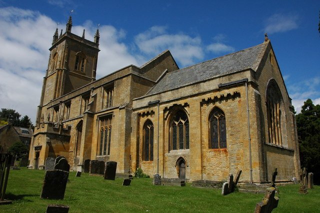
Parking at St. David’s Church or surrounding area. Facilities: Located in Moreton-in-Marsh.
- Distance:
- 2.20 miles
- Time:
- 1.20 hours
- Difficulty:
- Easy
- Terrain:
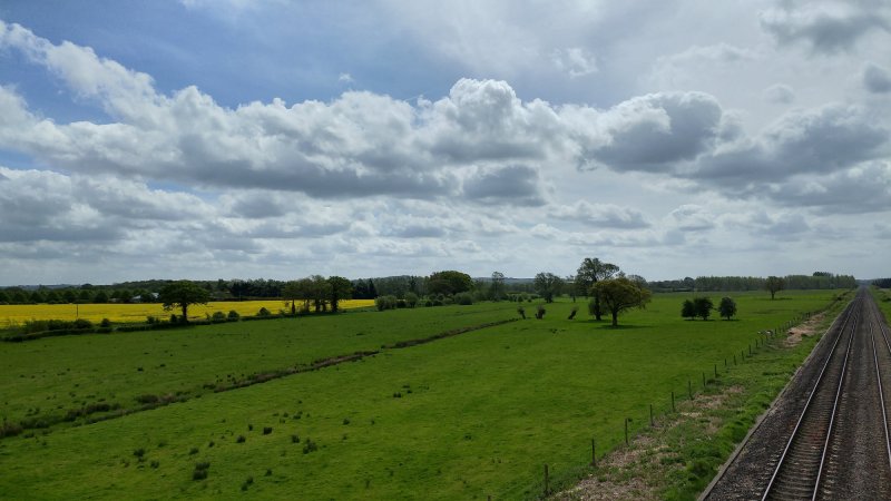
Footpaths, farmland.
- Facilities:
- Toilets, Cafe, Pub Nearby
- Get Directions:
-
Get driving directions to the starting point:
Want to remember this one?
Save it to your Dog Walks Near Me list so you can find it again when you are ready to head out.
3-Day Dog Walking Forecast
Ground Conditions
No reports yet. Walked this recently?
Dog-Centric Details
- Poo Bins Available:
- No
- Secure/Fenced Area:
- No
- Dog Water Source:
- No
- Dog Notes:
- EV Charger Nearby:
- No
- Fuel Station Nearby:
- No
- Livestock Information:
- Off-Leash Policy:
- Partial Off-Leash
- Dog Traffic:
- Moderate
- Seasonal Advice:
- Height Restriction:
- No
- Printable Version:
- Open & Print
Walk essentials
Need more bags for your next walk?
We use Pet Impact's ReSeacled bags - strong tie-handle poo bags made from 100% recycled plastic. Use code MAHLOW10 at checkout for 10% off.
Affiliate disclosure: if you buy through our Pet Impact link, we may earn a small commission at no extra cost to you. Why we recommend Pet Impact.
Moreton-in-Marsh in Gloucestershire is one of the principal market towns in the northern Cotswolds, located at the crossroads of the Fosse Way Roman road and the A44. This circular walk takes you to the south of the town, through farmland.
How to get there
Moreton-in-Marsh is located on the A429 and A44 crossover. M40 Junction 15 from the North (head down the A429) or M40 Junction 9 from the South (A34 then A44 North).
Walk
1 Start out from the car park at St. David’s Church, on Church Street. Heading away from the main road (A429) head right down the road Old Town. Follow this around the left handed bend, then carry on straight ahead of you, passing the Town Council building. Head on down the back of Fosseway Avenue keeping the allotments to your right. This alleyway will end on the road, if you cross over this to your left, then continue down the next alleyway.
2 You will see farmland ahead of you as you head down the alleyway. The path turns to the left slightly, before crossing over a bridge taking you over the stream. Continue then onward through the farmland, on the well-marked dirt path, which heads straight on. You will reach a farm building to your right, continue on past this until you are able to make a left turn.
3 Turn left and then walk onward towards a railway bridge. Continue on over this, crossing the track and then head straight on this track until you reach a gate which opens on to Evenlode Road.
4 At the road, turn left onto it, and walk alongside it down through and entering Moreton-in-Marsh. Continue on this road down until it reaches the A44.
5 Turn left onto the A44, and continue on with it crossing back over the railway track until you can take a left through to East Street.
6 Head down this street, with the school on your left and continue straight through to Church Street, where you will emerge at the start point of the walk.
Grid Reference: SP 206321
Safety Disclaimer
Outdoor activities always involve an element of risk. Routes, terrain, surfaces, weather, access, livestock presence, water levels, and parking arrangements can change at any time, and path conditions may deteriorate without notice.
You are responsible for your own safety and for the safety, supervision, and wellbeing of your dogs, children, and anyone else with you. Please assess conditions for yourself before setting out and decide whether the walk is suitable for your group.
Dress appropriately for the conditions and bring suitable equipment, food, water, leads, navigation tools, and anything else needed for a safe outing. Trail Tails Ltd is not responsible for loss, damage, injury, incident, or any consequences arising from use of this information.
Help Keep This Walk Accurate
If anything has changed or looks incorrect, please send us an edit or update suggestion.
Suggest an Edit or UpdateMap
Share this walk:
Other Walks Nearby
More walks nearby
Create a free account to keep exploring nearby walks and build a shortlist.
Create Free Account
Comments & Reviews (0)
Get More From This Walk!
Create a free account to save this walk, rate it, and share your experience.
Be the first to comment on this walk!