logo logo logo logo
  • England
    • North West
    • North East
    • Yorkshire
    • West Midlands
    • East Midlands
    • East of England
    • South West
    • South East
    • Greater London
    • Lake District
    • Peak District
    • South Downs
  • Scotland
    • Highlands
    • Lowlands
    • Cairngorms
  • Wales
    • North Wales
    • South Wales
    • Anglesey
    • Snowdonia
  • Blog
    • The Dog Blog
  • Dog Friendly
    • Holiday Cottages
    • Dogs Welcome
  • Store
  • High Dam

    Lake District


High Dam

Circular walk

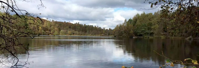
High Dam is a picturesque tarn close to Finsthwaite and Lakeside at the southern end of Windermere. Downloadable map available here.

We work hard to make this website the best it can be. If you've found it useful, please consider buying us a coffee to show your support.
Buy Me a Coffee at ko-fi.com

Useful Information

How to get there: Take the A590 from Newby Bridge, with signs to Barrow-in-Furness and Ulverston. Take the bridge over the River Leven toward Hawkshead. Head for Finsthwaite village and the car park located a little to the north.

Grid Reference: SD 367 882
Nearest Postcode: LA12 8BJ
Parking: Pay and display car park.

Distance

1.8 miles

Difficulty

Easy

Time

45min

Advertisement

The Walk

A circular walk around a tarn, at the southern end of Windermere lake.

Map with thanks to Ordnance Survey.

Walk

1. From the car park, head on the path which follows the river, ascending into the woods. Ignoring the bridge to your left and head right. Remain on this path, follow it through to a bend to the left and head alongside the river still. Continue on the main path, through a kissing gate and straight ahead, ignoring any turns. Remain on the path, with the dam to your left. Head over some footbridges to reach the second dam.

2. Cross over the footbridge to the right and continue on the path, following the water’s edge. Remain on the path, keeping the wall to your right. Pass on through a gap in the stone walls, then continue on the path as it ascends through the woods. Head over a footbridge to follow the path above the water. Pass through a gap in the stone wall and head left over another footbridge. Head back into the woodlands to cross another bridge and head straight on. Cross over the dam wall to take the path before the bridge to your right, which will lead you back down to the car park.

Similar Walks

Two further walks to consider in the Lake District.

Tarn Hows Tarn Hows, Lake District - Dog Walks Near Me

1 hr

Time

2.5 miles

Distance

Easy

Difficulty

Tarn Hows

Circular Walk

Lake District

Windermere Windermere, Lake District - Dog Walks Near Me

2hr 30min

Time

7 miles

Distance

Easy

Difficulty

Windermere

Linear Walk

Lake District

Enjoy this walk?

Say thanks with a coffee.

Our Affiliate Partners

North Face
client logo
Berghaus
Ordnance Survey
Jack Wolfskin UK
AATU
Dog Walks Near Me
  • Find dog walks across the UK
  • About Us
  • Sticker Competition
    (win £50)
Top Walk Areas
  • Peak District National Park
  • Lake District National Park
  • Cornwall Region
  • South East Region
Dogs Welcome
  • Find dog friendly businesses
    across the UK

  • Own a dog friendly business?
    Advertise with us (free listings
    are available)
The Dog Blog
  • A blog where we share additional content related to the wider-world

Contact Us
  • Email
© Dog Walks Near Me | Cookie & Privacy Policy