
Bakewell and the Monsal Trail
Walk Highlights
- Nearest Town:
- Bakewell
- Postcode:
- DE45 1GE
- Parking:
Monsal Trail car park, located off Station Road.
- Distance:
- 3.40 miles
- Time:
- 2.50 hours
- Difficulty:
- Easy
- Facilities:
- Toilets, Cafe
- Get Directions:
-
Get driving directions to the starting point:
Want to remember this one?
Save it to your Dog Walks Near Me list so you can find it again when you are ready to head out.
3-Day Dog Walking Forecast
Ground Conditions
No reports yet. Walked this recently?
Dog-Centric Details
- Poo Bins Available:
- Yes
- Secure/Fenced Area:
- No
- Dog Water Source:
- No
- Dog Notes:
Off-lead opportunities when not in Bakewell itself.
- EV Charger Nearby:
- No
- Fuel Station Nearby:
- No
- Livestock Information:
- Off-Leash Policy:
- Partial Off-Leash
- Dog Traffic:
- Busy
- Seasonal Advice:
- Height Restriction:
- No
- Printable Version:
- Open & Print
Bakewell is a well-loved market town offering a mixture of fantastic footpaths and trails to explore.
How to get there
Bakewell is located on the A6, between Buxton to the north, and Matlock to the south.
Walk
1 From the Monsal Trail car park, follow the signs onto the Monsal Trail, heading left towards Hassop. The Monsal Trail itself is a former railway line which was closed down in the 1960s and eventually converted into being a recreational route. Watch out for horses and cyclists here, particularly regarding your dog.
2 Follow on this route, and you will pass beneath a bridge. You will arrive at Hassop station just before reaching the second railway bridge.
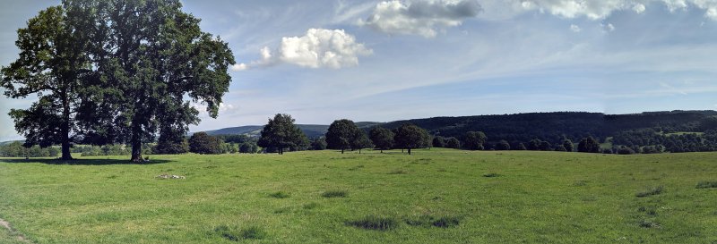
3 Continue from Hassop, taking the route off to the left. Pass through the gate to head up the track. As you reach the top of the hill, you will gain good views of the White Peak. Head on through a double gate to continue along the track. Head through another gate, onto a grass path, before passing through a further gate to begin the descent into Bakewell.
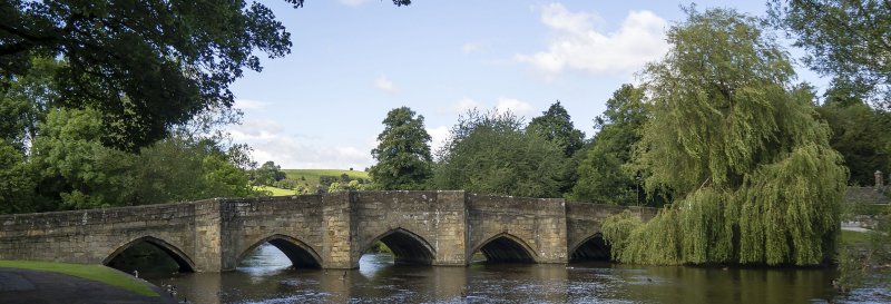
4 After passing through another gate, the path leads into a small wood and continues down into the town. Make sure your dog is on a lead at this point, as you will be reaching a road. Cross over the road and head across Holme Bridge.
5 Take a left upon reaching the main road. Follow the road beyond the fire station and into the town. Head on through the centre of Bakewell itself, crossing over the river on the bridge.
6 At the far side of the river, take the first road to your right. You will climb up a hill and head around the top to bring you back to the car park.
Grid Reference: SK 222 689
Safety Disclaimer
Outdoor activities always involve an element of risk. Routes, terrain, surfaces, weather, access, livestock presence, water levels, and parking arrangements can change at any time, and path conditions may deteriorate without notice.
You are responsible for your own safety and for the safety, supervision, and wellbeing of your dogs, children, and anyone else with you. Please assess conditions for yourself before setting out and decide whether the walk is suitable for your group.
Dress appropriately for the conditions and bring suitable equipment, food, water, leads, navigation tools, and anything else needed for a safe outing. Trail Tails Ltd is not responsible for loss, damage, injury, incident, or any consequences arising from use of this information.
Help Keep This Walk Accurate
If anything has changed or looks incorrect, please send us an edit or update suggestion.
Suggest an Edit or UpdateMap
Share this walk:
Other Walks Nearby
More walks nearby
Create a free account to keep exploring nearby walks and build a shortlist.
Create Free Account
Comments & Reviews (0)
Get More From This Walk!
Create a free account to save this walk, rate it, and share your experience.
Be the first to comment on this walk!